Westcliffe, Wet Mountain Valley — accommodation & travel guide
Westcliffe accommodation — places to stay, vacation rentals & inns
Short summary: Westcliffe accommodation serves travelers who want a quiet base in the Wet Mountain Valley for stargazing, hiking and private-ranch stays. The town (population 435 at the 2020 municipal census) is a small county seat with limited in-town services; most visitor inventory is a mix of vacation rentals, remote cabins and small inns. Plan to drive from Pueblo or Colorado Springs airports, verify road access for remote properties, and expect minimal public transport. This guide explains where to find rentals and inns, how to get there, what to do, and practical tips for a safe mountain stay; official town, county and federal sources are listed for detailed checks and seasonal advisories.
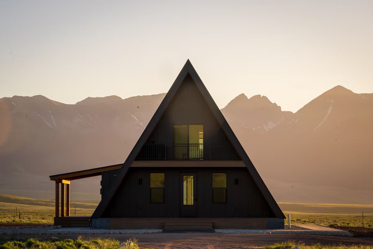
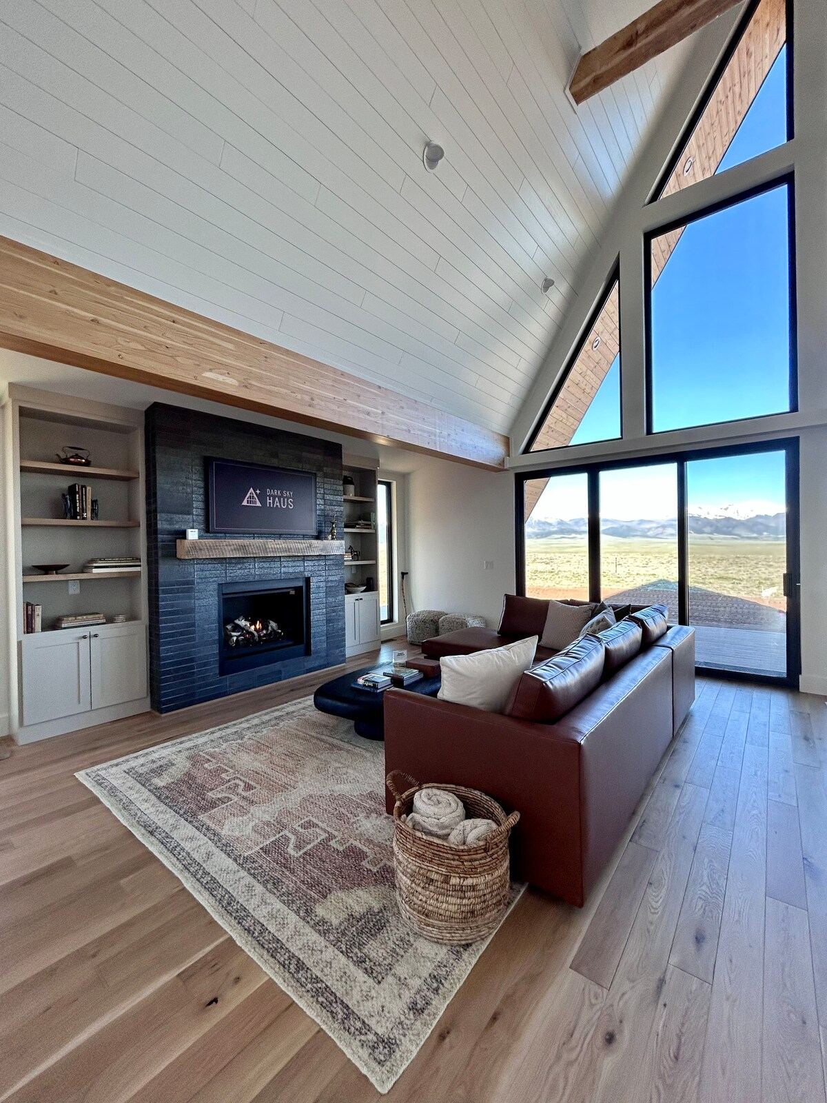
Welcome to Dark Sky Haus, an off-grid luxury A-frame in Colorado's Wet Mountain Valley. Nestled on 35.5 private acres, your A-frame getaway offers stunning, uninterrupted views of the majestic Sangre de Cristo Mountains and unparalleled stargazing opportunities. Conveniently located 20 minutes south of Westcliffe, a charming mountain town, we invite you to…
Westcliffe accommodation places you in the heart of Colorado’s Wet Mountain Valley: a small, high-elevation town that functions as Custer County’s seat and a practical base for outdoor recreation and dark-sky experiences. If you want low-traffic lanes, private-ranch rentals, locally run inns or short drives to high-country trailheads, Westcliffe’s inventory and rural setting make it an efficient choice. The town’s scale (435 people at the 2020 municipal census) means services are fewer than in regional hubs, so travelers prioritizing solitude, starry nights and ranch-style stays will find the area well-suited to their plans. (See official town and census sources in the references.)
For practical travel, note that Westcliffe is reached almost exclusively by road. The nearest airports—Pueblo Memorial and Colorado Springs—are roughly one to two hours away by private car, so most visitors plan a rental vehicle or pre-arranged transfer. Many vacation rentals advertise on the major short-term platforms and handfuls of small inns take reservations; properties range from upgraded downtown suites to secluded off-grid cabins set on acreage. This guide summarizes those practicalities and points you to official transport and local tourism sources for final route and booking checks.
If you need a quick itinerary: plan for at least two nights to enjoy evening stargazing and a full hiking or equestrian day in the Sangre de Cristo foothills. If you’re booking a remote cabin or ranch property, allow for dirt-road access and limited cell service; pack food and any necessary supplies if arriving late in the day. For municipal-level information or regulations, consult the Town of Westcliffe’s official pages and the Custer County tourism directory before finalizing dates. (All supporting sources included below.)
Where Westcliffe sits — geography, elevation and what that means for visitors
Westcliffe lies on the floor of the Wet Mountain Valley at roughly 7,700–7,800 feet (about 2,347–2,377 meters) in south-central Colorado, with the Sangre de Cristo Mountains rising to the east and west. The valley’s setting produces dramatic day–night temperature swings—warm afternoons in summer and cold nights year-round—so travelers should bring layered clothing and plan for weather extremes, especially at higher trail elevations. The surrounding topography also keeps populations low and light pollution minimal, making the area popular for night-sky viewing and rural retreats. Official mapping and town documents provide exact municipal coordinates and elevation references.
Because Westcliffe is the county seat of Custer County, it functions as a small service hub within a broader rural landscape. The incorporated town area is compact—municipal services, a few shops, and local dining clustered along Main Street—while much of the visitor inventory (cabins, ranch properties and vacation homes) sits on private roads and dispersed parcels outside town limits. That pattern matters when planning arrival times: many hosts request arrival before dark, and some roads require higher-clearance vehicles after winter storms. Consult property descriptions and the town’s planning documents for specific access notes before arrival.
The Wet Mountain Valley’s ecosystem and elevation create seasonal opportunities: late-spring wildflowers and early-summer horseback riding, summer hiking and mountain biking, and winter backcountry sports at elevation. But high-altitude sun and afternoon thunderstorms (especially June–August) mean hikers should start early and be prepared for sudden weather changes. Use local trailhead and Forest Service notices for current conditions; regional visitor guides and county maps identify key trailheads and scenic drives.
Getting to Westcliffe — airports, roads and practical ground transport
There’s no commercial airport in Westcliffe; visitors arrive by car from nearby regional airports or drive directly from Colorado population centers. Pueblo Memorial Airport is the closest commercial field by road (approximately 62 miles / ~100 km according to regional distance references), while Colorado Springs Airport is the larger option at roughly 80–84 miles by road. Many travelers fly into Colorado Springs and rent a vehicle there; driving from Denver is longer (around 110–140 miles depending on route) and often used by guests combining Westcliffe with other Colorado destinations. Check contemporary route planners before travel because mountain highways can be affected by weather and construction.
Public transit options are extremely limited for last-mile travel into the valley. There are no scheduled intercity rail or regular bus lines that serve Westcliffe directly; private shuttles or pre-arranged transfers from Pueblo or Colorado Springs are common when visitors prefer not to drive. If you rely on ride services, verify coverage from the airport of arrival; rural coverage can be spotty and pricier than urban markets. Hosts and local inns frequently list recommended transport providers and can sometimes arrange pickups with advance notice.
Road conditions matter. State Highway 69 and Highway 96 are the main approaches; some property drives and secondary roads are unpaved. In winter and shoulder seasons, local snowplowing is limited outside the main town, and mountain passes or forest roads may be inaccessible to two-wheel-drive vehicles. Confirm access and parking with your host, and consider renting an all-wheel or four-wheel vehicle for winter travel or remote cabin stays. Official town packets and regional road guides should be consulted for the most current advisories.
Types of accommodation you’ll find in Westcliffe
Short-term vacation rentals: The majority of visitor listings in the area appear on major short-term rental platforms and small local directories. These offer everything from one-bedroom downtown suites to multi-bedroom cabins and ranch-style properties on acreage. Many listings advertise pet-friendly policies and private outdoor space—attractive features for families and groups seeking privacy or access to stargazing sites. Because stock is relatively small compared to resort towns, book early for summer and holiday weekends. Public listings and market-data providers give an overview of active inventory and common amenities.
Small inns and boutique suites: A handful of locally run inns, guest houses and boutique-suite operations provide predictable booking windows and — in some cases — breakfast or concierge-style guidance. These properties can be convenient for travelers who prefer on-site hosts, simpler logistics on arrival, and central town locations near food and services. Inns often provide better cellular connectivity than remote cabins, which is useful if you require consistent internet for work or planning. Check individual inn websites for reservation policies and check-in details.
Ranches and remote cabins: For travelers seeking seclusion, properties on private ranches or remote cabins are common in the wider Custer County area. These rentals frequently include extensive outdoor space, direct access to private trails or adjoining public lands, and minimal nearby services; they can be a strong match for stargazing groups, photographers, and families who want a base for horseback riding or off-grid-style stays. Confirm road access, utility arrangements and any additional service fees before booking; hosts will usually list whether a 4x4 vehicle is recommended.
What to do — outdoor activities and natural highlights
Hiking and trails: Westcliffe is a launch point for numerous trailheads that access the Sangre de Cristo foothills and higher alpine terrain. Day-hikes vary from valley-floor rambles to steep ascents with panoramic mountain views; several well-signposted routes are within short drives. For longer backpacking trips, consult U.S. Forest Service maps and local trail guides to plan water caches and campsite permits. Summer is peak hiking season, while spring and autumn provide cooler temperatures and fewer crowds.
Horseback riding, ranch visits and scenic drives: The Wet Mountain Valley has an equestrian tradition—several local operators and ranch hosts arrange guided rides or allow guest riders by prior reservation. Scenic drives across the valley and along adjacent forest roads are another low-effort way to see the landscape; these often lead to trailheads, viewpoints, and secluded picnic spots. Road conditions vary by season, so choose routes compatible with your vehicle and weather forecast.
Fishing and wildlife viewing: High-country streams, alpine lakes and private-stock ponds near Westcliffe host trout and other angling opportunities; local outfitters and fishing guides can assist with licensing and access. Wildlife viewers commonly spot mule deer, elk, and a variety of birds—bring binoculars and practice safe distance protocols. For any activity on federal land, follow posted regulations and carry the required permits or licenses for hunting or fishing seasons.
Stargazing, dark skies and photography tips
Dark-sky access: Westcliffe is widely recommended among regional guides and accommodation platforms for dark-sky viewing because of its valley location and limited local lighting. Visitors who prioritize night photography or astronomy choose remote rentals or fields a short drive from town to minimize light interference. For dates and special stargazing events, check local tourism calendars and coordinate with hosts in advance to secure open land or private viewing spots.
Practical stargazing setup: Expect cold nights even when daytime temperatures feel warm—bring insulated layers, a headlamp with a red-light option to preserve night vision, and a robust tripod for long-exposure photography. If you’re using a rental with private acreage, confirm neighbors’ light usage and any restrictions; some properties explicitly advertise their suitability for astronomy. Battery power banks and backup light sources are helpful in remote areas.
Photography permits and respectful use: If planning a commercial shoot or drone usage, check Custer County and U.S. Forest Service rules; many scenic locations allow casual photography but require permits for professional or drone shoots. Be aware that private-ranch accesses require host permission and that night noise and campfires may be subject to burn bans or town ordinances—verify current local orders before lighting fires or staging evening events.
Food, services and practical amenities in town
Local dining and basic shopping: Westcliffe’s small commercial core includes independent restaurants, cafés, and a local market. Options are suitable for breakfast, lunch and casual dinner service, but the selection is limited compared with regional cities; some establishments operate seasonal hours and may close mid-week outside of summer months. If you have dietary requirements or prefer specialty groceries, plan a stop in Pueblo or Colorado Springs en route. Consult local business pages and the town’s website for current operating hours.
Medical, fuel and mechanical services: The town provides basic medical and fuel services, but major medical facilities and comprehensive auto services are located in larger regional centers. For longer stays or remote property bookings, carry a basic first-aid kit and plan for vehicle contingencies; roadside assistance coverage and a spare tire kit are recommended. For urgent or complex medical care, the nearest larger hospitals are in Pueblo and Colorado Springs.
Connectivity and work-from-stay considerations: Many vacation rentals are rural and may have limited or variable internet connectivity. If reliable broadband is essential for work, verify the property’s stated internet speed or seek centrally located inns and suites that advertise higher-speed connections. Town planning documents and local host notes occasionally reference municipal broadband initiatives or service improvements—ask hosts for speed-test screenshots or alternative solutions (mobile hotspot) before arrival.
Day trips and nearby destinations worth combining with Westcliffe
Silver Cliff and local history: Immediately adjacent to Westcliffe is the small town of Silver Cliff—historical markers, local museums and scenic drives link the two communities. A short drive through the valley connects other small towns and access points for regional trails, making Westcliffe a logical base for day excursions across Custer County. Local visitor guides and county maps list museums, interpretive signs and seasonal events you can fold into a day plan.
Salida, Buena Vista and Collegiate Peaks: If you want more developed outdoor-service towns, Salida and Buena Vista lie to the north and provide river runs, outfitters, and expanded dining and lodging options; both are within a couple of hours’ drive and are frequently combined with Wet Mountain Valley itineraries. These towns are practical if you plan whitewater, alpine passes, or longer-range sightseeing in the Collegiate Peaks corridor.
Great Sand Dunes and mountain circuits: Driving a few hours south or southwest opens access to the Great Sand Dunes National Park and other southern Colorado attractions. Westcliffe works as a lesser-trafficked overnight stop for travelers moving between Front Range cities and southern Colorado destinations; plan route timing and road choices during winter months when passes can be closed.
Booking, seasons and practical travel tips
When to visit: Peak season for Westcliffe is late spring through early fall—especially June through September—when trails are most accessible and weather is favorable for high-country activities. Shoulder seasons (May and October) offer fewer crowds and strong photographic color but bring more variable weather. Winter visits suit travelers pursuing solitude, snowshoeing, or low-traffic photography, but be prepared for deeper snow, limited services and some closed access roads; hosts often publish winter-access notes.
Booking strategy and property checks: Because the area’s inventory is modest, use multiple booking sources—platform listings, local inn websites, and the official Custer County visitor directory—to compare availability and host rules. Confirm arrival times, road-access notes, pet policies, and amenities (heating systems, hot water, backup power) in writing. For remote ranch stays, verify whether the property is fenced, whether livestock are present, and where parking is provided.
Safety, mountain etiquette and environmental responsibility: Bring layered clothing, a first-aid kit, and plenty of water; high elevation and strong sun require sunscreen and hydration. Practice Leave No Trace when hiking and camping, respect private property boundaries, and follow wildfire restrictions for campfires. Consult U.S. Forest Service and local town pages for current fire-bans or forest orders before igniting fires or using fireworks. Hosts and county tourism pages typically summarize local rules relevant to visitors.
Population (regional): 4,704 (2020 decennial census, CCD) — Westcliffe CCD / Custer County area (regional), 2020. Source
Nearest commercial airport distance: ~62 miles / 100 km (road) — Pueblo Memorial Airport to Westcliffe (regional road distance), as published online. Source
Nearest major airport distance: ~80–84 miles / 129–135 km (road) — Colorado Springs Airport to Westcliffe (regional road distance), as published online. Source
What travelers consistently mention about Westcliffe
Strong appeal for stargazing and dark-sky experiences
Across short-term platforms and regional visitor pages guests consistently choose Westcliffe-area listings and rural cabins for unobstructed night skies and astrophotography. Hosts commonly advertise properties for stargazing, and regional directories highlight the town’s low light pollution; this makes it a repeat draw for astronomy-focused visitors. Sources: platform listings, local directory and short-term rental market data.
Preference for private, rural rentals with variable access
Guest inventories show many properties located on private acreage and ranch land—popular for privacy and outdoor access—but hosts often warn of unpaved arrival roads, limited cell service, and winter-access considerations. Travelers report preferring these rentals for solitude but advise confirming vehicle and access requirements before booking. Sources: major listing sites and local inn pages.
Limited in-town services; plan supplies and fuel
Because Westcliffe is a small municipal seat with a small year-round population, visitor feedback and town documents recommend stocking groceries and fuel in regional hubs (Pueblo or Colorado Springs) for longer trips. Local businesses exist but can operate seasonal hours; guests should confirm services and bring essentials when staying at remote cabins. Sources include the town website, the county visitor directory and transport distance references.
Frequently asked questions about Westcliffe stays
How do I get to Westcliffe, Colorado, and what are the nearest airports?
Westcliffe is best reached by car; the town sits on State Highway 69 in the Wet Mountain Valley. The nearest commercial airports are Pueblo Memorial Airport (approx. 62 miles/100 km by road) and Colorado Springs Airport (approx. 80–84 miles/129–135 km by road), both offering car-rental options; Alamosa and Denver are farther options for regional and national connections. Public transport is minimal—plan for a rental car or arranged transfer from Pueblo or Colorado Springs. For accurate road distances and flight options at the time of travel, check the airport websites or ground-transport providers before booking. (Sources in structured fields.)
What kinds of places to stay are available in Westcliffe?
Westcliffe’s accommodation mix includes short-term vacation rentals (cabins and ranch homes), small locally run inns and suites, and a handful of boutique rooms and guest houses. Online platforms list roughly 25–35 active vacation-rental listings for the Westcliffe area, while a small cluster of inns and suites handle walk-in and reservation business. Many rental properties sit outside town on private acreage and appeal to visitors seeking privacy, pet-friendly stays, or stargazing access. Check each listing’s amenities and access (dirt roads, utility details) before booking. (Sources in structured fields.)
Is Westcliffe good for stargazing and outdoor activities year-round?
Yes—Westcliffe and the surrounding Wet Mountain Valley are frequently recommended for dark-sky viewing and outdoor recreation. The town’s high elevation (around 7,700–7,800 ft / ~2,347–2,377 m at valley floor) and distance from major light pollution create reliable night-sky visibility in clear weather months; summer and early fall are popular for alpine hiking and horseback riding, while shoulder seasons still offer lower-traffic access and winter recreation nearby. Always check seasonal weather and road conditions; some forest and mountain roads may close or require high-clearance vehicles in winter. (Sources in structured fields.)
Are there grocery, dining, and fuel services in Westcliffe?
Westcliffe is a small town with limited commercial services. You’ll find basic grocery and dining options, fuel stations, and a few independent shops; for broader supermarket choices, specialty gear, or large-scale medical services plan a stop in Pueblo or Colorado Springs. Local restaurants and markets may have seasonal hours—especially off-peak—so verify opening times before arrival. Bringing some supplies for remote stays is advisable if you’re booked on a nearby ranch or cabin. (Sources in structured fields.)
What permit, rules or seasonal restrictions should I know about visiting public lands near Westcliffe?
Westcliffe sits near national-forest access points and multiple trailheads. Recreation on U.S. Forest Service and Bureau of Land Management land follows federal rules (campfire restrictions, camping regulations, permit requirements for specific areas). Seasonal restrictions—forest-closure orders, burn bans, and wildlife-protection closures—can change rapidly, particularly in fire season; check the relevant USFS district and local county announcements before backcountry travel. For commercial activities or special events, coordinate with Custer County or the Town of Westcliffe. (Sources in structured fields.)
Sources and review notes
Reviewed 2026-08-27. Verify current schedules, prices and access at the source.